How does geofencing for fleet management actually work, and which geofencing use cases pay for themselves? How it works, ten production use cases, setup that scales, and where geofencing accuracy runs out.
A geofence is one of the oldest features in telematics, and one of the most wasted. Most fleets switch it on to answer a single question, tell me when a truck leaves the yard, and then stop. Within a month the alert folder fills with four thousand notifications a day that nobody reads, and the feature quietly becomes noise the operations team has trained itself to ignore. That is the difference between geofencing as a checkbox and geofencing as an operating system: not the boundary, but what you attach to it.
Geofencing for fleet management is the use of virtual boundaries drawn around real-world locations, depots, customer sites, charging hubs, restricted zones, so that a vehicle entering, leaving, or lingering in one automatically triggers an action: an alert, a log entry, a workflow step, or an escalation to a named person. Done with discipline, it turns location data into decisions. Done without it, it produces the ignored folder above.
We run geofencing at production scale inside the platforms we engineer, including the operational backbone for an electric vehicle fleet of more than 3,000 vehicles that processes over 1 billion telemetry events each month. This guide covers how geofencing works, the ten use cases that actually pay for commercial fleets, how to set geofences up so people act on them, where geofencing accuracy runs out, and how compliance regimes such as India's AIS-140 change the picture. Every recommendation below comes from running the system, not from imagining it.
How geofencing works in fleet management
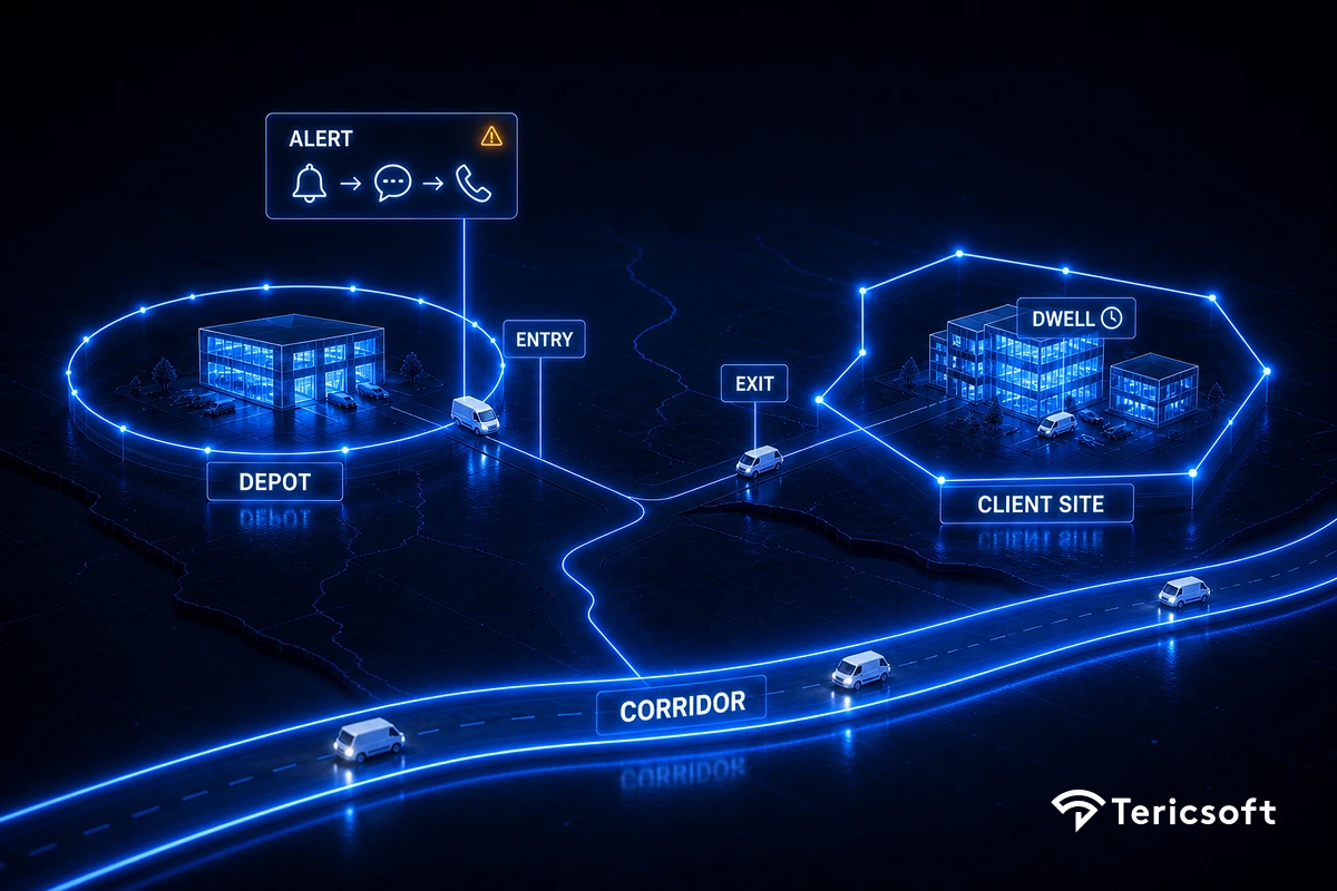
To understand how geofencing works, start with the mechanics, because they are simple, and then spend your attention on the part most fleets skip. Geofencing runs on the same GPS tracking data any device or manufacturer telematics feed already produces, so no special hardware is required. Four steps turn that raw position into an operational event.
- Boundary definition. A geofence is drawn on a map as a circle, which is fast and good for depots and hubs, or a polygon, which is precise and good for irregular sites, corridors, and zones. Modern platforms hold thousands of fences per fleet.
- Position matching. Each vehicle's GPS position streams into the platform, which continuously evaluates every vehicle against every relevant fence.
- Event triggers. There are three primitives: entry, exit, and dwell, which means inside or outside a fence longer than a set threshold. Everything else is built from these three.
- Attached actions. This is the part most fleets skip. Each trigger should map to a defined action: a log entry, a ranked alert, an automated workflow step, or an escalation to a named role. A trigger with no action attached is not monitoring, it is decoration.
The type of fence you choose is an operational decision, not a cosmetic one, because it decides how many false triggers you generate.
The mechanics are the easy twenty percent. The value, and the failure, live entirely in step four and in the discipline of how you rank and maintain what those triggers do.
The 10 geofencing use cases that pay for themselves
These are the geofencing use cases we see earn their keep in real operations, ordered roughly from the easiest wins to the ones that need the most discipline. They apply across vans, buses, and geofencing for trucks alike, though heavy-vehicle operators lean hardest on corridor compliance and yard management.
1. Depot and yard automation. Entry and exit events replace manual gate logs with automatic trip start and end stamping, yard-time measurement, and shift reconciliation. Ten seconds of admin saved per movement, multiplied by thousands of movements a month, is a real number.
2. Customer-site SLA evidence. A fence around each client site timestamps every arrival and departure automatically, which turns a 'your vehicle was late' dispute into a lookup. Paired with second-by-second trip replay, it is the difference between arguing and showing.
3. Route-corridor compliance. For contracted routes, employee transport, school runs, and high-value cargo, a corridor polygon around the approved route turns any deviation into an immediate alert rather than a next-day report. This is a safety control as much as a cost one.
4. Safety and escort zones. In employee transport, geofences enforce the promises made to clients: restricted areas avoided, night-route rules honored, deviation alerts on trips that carry escort obligations. The fence is the auditable proof that the policy ran. See how safety rules belong inside routing itself.
5. Theft and unauthorized-use detection. Exit events outside working hours, vehicles appearing in fences they have no business in, and dwell at unknown locations at two in the morning all surface misuse that daily reports never catch. Combined with device-disconnect alerts, geofencing closes the classic leakage pattern of unplugging the tracker to run an off-book trip.
6. EV charging-location intelligence. Fences around charging hubs verify that planned charging actually happened, the right vehicle, the right window, the right duration, and flag charging at unauthorized and often more expensive locations. At electric-fleet scale, charging-window discipline is a line on the profit and loss. See EV charging operations in depth.
7. Dwell-time and detention analytics. Dwell events quantify where vehicle-hours die: forty minutes average at a customer loading bay, twenty-five at a toll cluster, ninety idle at a hub between assignments. Dwell data is the raw material of utilization recovery and of detention-fee claims backed by evidence rather than memory.
8. Automated arrival workflows. Entry triggers do work: notify the consignee, open the gate ticket, start the loading clock, ping the next driver in the queue. Every notification a human does not have to send is seconds saved and an error avoided.
9. Compliance and restricted-zone enforcement. No-go zones, weight-restricted roads, environmental zones, and client-prohibited areas are enforced as alert-on-entry fences, with the event log serving as your compliance record.
10. Cross-border and jurisdiction logging. For fleets crossing state or national boundaries, fence events create automatic logs for tax, permit, and regulatory reporting that drivers would otherwise reconstruct from memory at the end of a shift.
How to set up a geofence people actually act on
The failure mode is universal: a team fences everything, attaches an email alert to all of it, and within a month operations has learned to ignore the folder. Here is how to set up a geofence, and a fleet of them, so that does not happen.
- Give every fence an owner and a consequence. If no named role acts on a trigger, delete the fence. A geofence is a policy statement, not a pin on a map.
- Rank your geofence alerts. A depot entry is a log line. A night-time exit is an alert. A corridor breach on an escorted trip is an escalation. Route them differently, and let the critical ones chase a human through an escalation ladder of application push, then message, then an AI voice call until someone acknowledges.
- Use dwell thresholds, not raw events. 'Entered customer site' is trivia. 'Inside customer site thirty-five minutes past the detention window' is money. Dwell is where most of the value hides, so tune the threshold per site rather than alerting on the crossing itself.
- Size the fence to the site and the signal. A fence drawn too tight around a gate will fire false entries and exits every time a vehicle idles near the boundary or GPS drifts. Add a margin, and enlarge fences in dense urban areas where position error is larger, which the next section quantifies.
- Audit fences quarterly. Sites move, contracts end, routes change. Stale fences generate false alarms, and false alarms are what kill the whole system's credibility. A quarterly review that retires dead fences is the cheapest reliability work you will do.
- Design for scale from day one. At fifty vehicles you can read events. At 1,000 or more vehicles only exceptions matter, and the platform must evaluate thousands of fences continuously and surface only what needs action. That is an architecture question, not a feature checkbox. See why the data layer decides everything.
Geofencing accuracy and where it runs out
Geofencing accuracy is not a property of the fence, it is a property of the position feeding it, and most 'geofencing is unreliable' complaints trace to two causes that have nothing to do with the boundary: position error in the environment, and low update frequency in the device.
Under open sky, a modern GPS receiver is typically accurate to within about five meters, according to the United States government's GPS information service. (GPS.gov accuracy) That is tight enough for most depot and customer-site fences. The problem is that fleets do not operate only under open sky.
Those wider errors are not the fence misbehaving, they are multipath: in dense cities the signal bounces off tall buildings before it reaches the receiver, so a position that is a few meters out under open sky can degrade to tens of meters, and as much as fifty meters in the worst urban canyons, according to GNSS industry and research data. (u-blox) (GNSS research)
The second, less obvious cause is update frequency. A device reporting every thirty seconds can carry a fast vehicle well past a small fence between two pings, so the entry is recorded late or missed entirely. That reads as a geofence failure, but it is a sampling problem, and it is fixed by raising the report rate for vehicles that pass through tight fences, not by redrawing the boundary. Understanding this is the difference between blaming the map and fixing the feed.
Geofencing also has a harder limit worth stating plainly. It knows where a vehicle is relative to a boundary. It does not know whether that vehicle is earning, healthy, or compliant with anything non-spatial. In mature operations, geofencing is one signal inside a wider intelligence layer, where fence events combine with state of charge, trip status, driver assignment, and SLA context to produce decisions rather than dots. That is the difference between a tracking feature and an AI telematics platform, and it is why fence events in our deployments feed the same ranked exception queue as every other operational signal.
Geofencing and AIS-140 compliance for fleets in India
For fleets operating in India, geofencing is not only an efficiency tool, it is part of a legal baseline. AIS-140 is the Automotive Industry Standard issued under the Ministry of Road Transport and Highways that mandates vehicle location tracking devices and emergency panic buttons for public service and commercial vehicles, with geofencing support built into the standard. (Ministry of Road Transport and Highways) In practice that means an operator running covered vehicles already has the position feed geofencing needs, and often a regulatory reason to use it.
Two India-specific details matter for setup. First, compliant devices integrate with state backend and permit systems, so geofence events can double as the audit trail regulators and clients expect, rather than a separate log the fleet maintains by hand. Second, positioning in India increasingly uses NavIC, the country's own satellite navigation system, alongside GPS, which improves availability in regions where a single constellation struggles. The practical takeaway is the same one that runs through this whole guide: the compliance mandate gets you the data, but it is the discipline of owners, ranked alerts, and dwell thresholds that turns a mandated tracker into an operational advantage instead of another box ticked for the permit.
Key lessons
- A geofence without an attached action is noise waiting to be ignored. Fence, then trigger, then owner, then consequence, or do not draw it.
- The three primitives build everything. Entry, exit, and dwell are the whole vocabulary, and dwell is where the money hides, so master it first.
- Rank ruthlessly. Logs, alerts, and escalations are different products, and treating them the same destroys all three.
- Blame the feed, not the fence. Most accuracy complaints are position error or low update frequency, both of which are fixed upstream of the boundary.
- Geofencing compounds with context. Location events joined to SLA, charging, and dispatch data are worth ten times location events alone.
See geofencing running inside a real fleet
Every use case above is running in production somewhere today. If you operate more than five hundred vehicles, anywhere, and you want to see geofencing working live rather than described in a feature list, book a technical deep dive. We will show corridor compliance, charging verification, and dwell analytics on a real production fleet, walk your team through how the ranked exception queue decides what reaches a human, and map what your current geofence setup is missing.
About Tericsoft
We build fleet technology on one belief about geofencing: the boundary is trivial, and the discipline is everything. Anyone can draw a circle on a map. The work that decides whether it earns money is the layer underneath, ranking a night-time exit differently from a depot entry, tuning a dwell threshold to a detention window, sizing a fence to the signal it will actually receive, and wiring the critical events into an escalation that chases a named person until the problem is owned. Most platforms stop at the alert. We are interested in what happens after it.
That is the work we do for operators who have outgrown a tracking feature and need geofencing to behave like an operating system: fleets large enough that only exceptions matter, and complex enough that a location event is worthless until it is joined to charge, trip, and SLA context. If your current setup shows you where every vehicle is and changes nothing when one crosses a line, that gap is the problem we solve.

Virtual boundaries around depots, sites, and hubs; a vehicle entering, exiting, or dwelling in one triggers an alert, log, or escalation.
The platform matches each vehicle's streamed GPS position against every fence and fires entry, exit, or dwell events. No extra hardware.
About five meters under open sky, twenty to fifty in cities. Most errors come from low device report rates, not the fence itself.
As many as have an owner and a consequence. Rank triggers into logs, alerts, and escalations, and audit fences quarterly.
AIS-140 requires tracking devices and panic buttons on public and commercial vehicles, with geofencing support built in.